


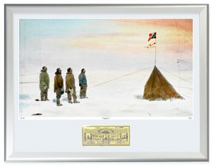
Limited Edition set of Roald Amundsens maps from the South Pole expedition 1910-1914. All the maps are printed in full size on quality paper and include handwritten notes and dates, stains, and signs of wear and tear.
The replica collection includes both maps used on a daily basis during the expedition and handmade originals used to illustrate Amundsens book The South Pole. There are 10 maps in one set.
The limited edition set of Roald Amundsens maps is printed in only 100 copies and will never be reprinted in full size. All maps and each set are individually numbered and initialled by the director of the Fram Museum.
Title/Tittel
Roald Amundsens Maps
Publisher/Forlag:
The Fram Museum


Reviews
There are no reviews yet.